
Volcanoes National Park topographic map
Interactive map
Click on the map to display elevation.
About this map
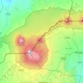
Name: Volcanoes National Park topographic map, elevation, terrain.
Location: Volcanoes National Park, Musanze, Northern Province, Rwanda (-1.56835 29.39767 -1.35906 29.70430)
Average elevation: 7,710 ft
Minimum elevation: 4,439 ft
Maximum elevation: 14,678 ft
Other topographic maps
Click on a map to view its topography, its elevation and its terrain.
Musanze
Rwanda > Northern Province > Musanze
Musanze, Northern Province, Rwanda
Average elevation: 7,372 ft