
Make a donation
Gear up for your next adventure:
As an Amazon Associate, this site earns from qualifying purchases at no extra cost to you.
Cap Blanc topographic map
Click on the map to display elevation.
Make a donation
Gear up for your next adventure:
As an Amazon Associate, this site earns from qualifying purchases at no extra cost to you.
About this map
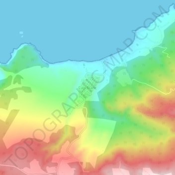
Name: Cap Blanc topographic map, elevation, terrain.
Location: Cap Blanc, Aïn El Kerma, Daïra Boutlelis, Oran, Algérie (35.65073 -1.02251 35.69073 -0.98251)
Average elevation: 400 ft
Minimum elevation: -3 ft
Maximum elevation: 1,168 ft
Make a donation
Gear up for your next adventure:
As an Amazon Associate, this site earns from qualifying purchases at no extra cost to you.
Other topographic maps
Click on a map to view its topography, its elevation and its terrain.
Sebkha d'Oran
Algérie > Oran > Daïra Boutlelis
La Sebkha d'Oran est un lac situé à 15 km au sud d'Oran dans la commune de Misserghin et distante de 12 km de la mer Méditerranée. Elle est une dépression, fermée à 110 mètres d’altitude, limitée au Nord par le massif du Murdjajo et au Sud par le massif de Tessala. La sebkha occupe le fond de cette…
Average elevation: 581 ft