
Make a donation
Gear up for your next adventure:
As an Amazon Associate, this site earns from qualifying purchases at no extra cost to you.
Carrazeda de Ansiães topographic map
Click on the map to display elevation.
Make a donation
Gear up for your next adventure:
As an Amazon Associate, this site earns from qualifying purchases at no extra cost to you.
Carrazeda de Ansiães
Carrazeda de Ansiães has a warm-summer Mediterranean climate (Köppen: Csb) characterized by cool winters and warm to hot summers with cool nights due to its altitude.[4] As with other municipalities near the Douro Valley, altitude plays a role in temperature. Places closer to the valley at lower altitudes generally have higher temperatures (averaging around 16 °C (61 °F)), and hot to very hot summers (Köppen: Csa), while places higher in altitude (e.g. 800 m (2,600 ft)) tend to have lower average temperatures, generally around 11 °C (52 °F), with temperatures similar to those shown in the climate box below.
Make a donation
Gear up for your next adventure:
As an Amazon Associate, this site earns from qualifying purchases at no extra cost to you.
About this map
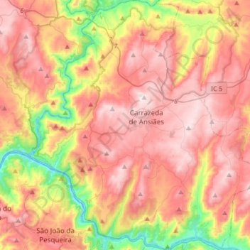
Name: Carrazeda de Ansiães topographic map, elevation, terrain.
Location: Carrazeda de Ansiães, Bragança, Portugal (41.13549 -7.43189 41.33852 -7.18654)
Average elevation: 1,765 ft
Minimum elevation: 246 ft
Maximum elevation: 2,907 ft
Make a donation
Gear up for your next adventure:
As an Amazon Associate, this site earns from qualifying purchases at no extra cost to you.
Other topographic maps
Click on a map to view its topography, its elevation and its terrain.
Make a donation
Gear up for your next adventure:
As an Amazon Associate, this site earns from qualifying purchases at no extra cost to you.