Geolocate

Whately topographic map

Click on the map to display elevation.

About this map

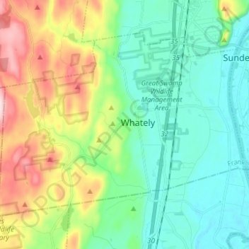
Name: Whately topographic map, elevation, terrain.

Location: Whately, Franklin County, Massachusetts, United States (42.40555 -72.70439 42.47288 -72.58110)

Average elevation: 377 ft

Minimum elevation: 89 ft

Maximum elevation: 1,102 ft

Franklin County trails, hiking, mountain biking, running and outdoor activities

Other topographic maps

Click on a map to view its topography, its elevation and its terrain.

Fort Lucas

United States > Massachusetts > Franklin County

Average elevation: 876 ft

Mount Hermon

United States > Massachusetts > Franklin County > Gill

Average elevation: 325 ft

Bear Swamp

United States > Massachusetts > Franklin County > Ashfield

Average elevation: 1,509 ft

Mount Ram

United States > Massachusetts > Franklin County

Average elevation: 577 ft

Shelburne

United States > Massachusetts > Franklin County

Average elevation: 873 ft

Pitt Hill

United States > Massachusetts > Franklin County > Orange

Average elevation: 955 ft

Mount Hermon

United States > Massachusetts > Franklin County > Gill

Average elevation: 325 ft

Gear up for your next adventure:

🦶Hiking Gaiters - Keep debris and water out of your boots
🔭Compact Binoculars - HD vision for scouting terrain and identifying distant landmarks
🧭Orienteering Set - Complete compass and map reading kit
🪶Survival Guide Book - Expert advice for emergency preparedness
🪶Trail Camera - Capture wildlife on your hikes

As an Amazon Associate, this site earns from qualifying purchases at no extra cost to you.