
Thank you for supporting this site ❤️
Make a donation
Make a donation
Gear up for your next adventure:
As an Amazon Associate, this site earns from qualifying purchases at no extra cost to you.
Nußhardt topographic map
Click on the map to display elevation.
Thank you for supporting this site ❤️
Make a donation
Make a donation
Gear up for your next adventure:
As an Amazon Associate, this site earns from qualifying purchases at no extra cost to you.
Nußhardt
Der Nußhardt liegt am FGV-Hauptwanderweg Höhenweg zwischen dem FGV-Unterkunftshaus Seehaus und dem Schneeberg. Die Besteigungsanlage wird von der FGV-Ortsgruppe Vordorf betreut.
Thank you for supporting this site ❤️
Make a donation
Make a donation
Gear up for your next adventure:
As an Amazon Associate, this site earns from qualifying purchases at no extra cost to you.
About this map
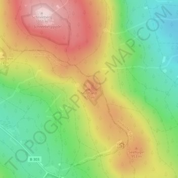
Name: Nußhardt topographic map, elevation, terrain.
Average elevation: 2,812 ft
Minimum elevation: 2,267 ft
Maximum elevation: 3,432 ft
Thank you for supporting this site ❤️
Make a donation
Make a donation
Gear up for your next adventure:
As an Amazon Associate, this site earns from qualifying purchases at no extra cost to you.