Geolocate

Washington topographic map

Interactive map

Click on the map to display elevation.

About this map

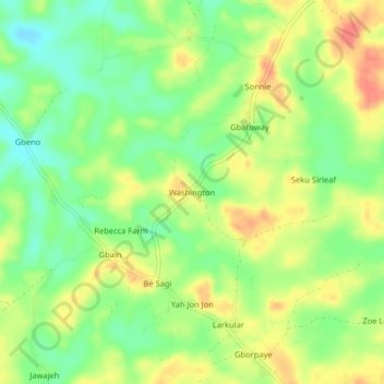
Name: Washington topographic map, elevation, terrain.

Location: Washington, Todee, Montserrado County, Liberia (6.51200 -10.48277 6.55200 -10.44277)

Average elevation: 295 ft

Minimum elevation: 210 ft

Maximum elevation: 387 ft

Other topographic maps

Click on a map to view its topography, its elevation and its terrain.

Grimes Farm

Liberia > Montserrado County > Todee

Grimes Farm, Todee, Montserrado County, Liberia

Average elevation: 259 ft

Carter

Liberia > Montserrado County > Todee

Carter, Todee, Montserrado County, Liberia

Average elevation: 440 ft

Dickson

Liberia > Montserrado County > Todee

Dickson, Todee, Montserrado County, Liberia

Average elevation: 308 ft

Bonner

Liberia > Montserrado County > Todee

Bonner, Todee, Montserrado County, Liberia

Average elevation: 200 ft