
Thank you for supporting this site ❤️
Make a donation
Make a donation
Gear up for your next adventure:
As an Amazon Associate, this site earns from qualifying purchases at no extra cost to you.
Luninets District topographic map
Click on the map to display elevation.
Thank you for supporting this site ❤️
Make a donation
Make a donation
Gear up for your next adventure:
As an Amazon Associate, this site earns from qualifying purchases at no extra cost to you.
About this map
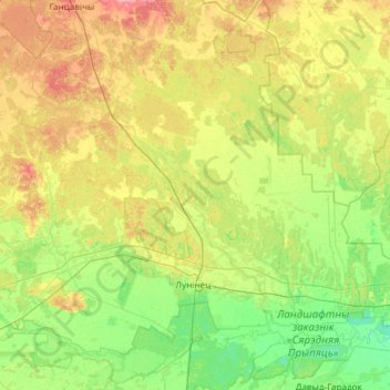
Name: Luninets District topographic map, elevation, terrain.
Location: Luninets District, Brest Region, Belarus (52.10760 26.36766 52.71240 27.55961)
Average elevation: 463 ft
Minimum elevation: 397 ft
Maximum elevation: 600 ft
Thank you for supporting this site ❤️
Make a donation
Make a donation
Gear up for your next adventure:
As an Amazon Associate, this site earns from qualifying purchases at no extra cost to you.
Other topographic maps
Click on a map to view its topography, its elevation and its terrain.
Любашево
Belarus > Brest Region > Hantsavichy District > Любашевский сельский Совет
Average elevation: 528 ft