
Make a donation
Gear up for your next adventure:
As an Amazon Associate, this site earns from qualifying purchases at no extra cost to you.
Ruisseau de Bise topographic map
Click on the map to display elevation.
Make a donation
Gear up for your next adventure:
As an Amazon Associate, this site earns from qualifying purchases at no extra cost to you.
About this map
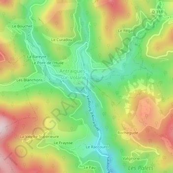
Name: Ruisseau de Bise topographic map, elevation, terrain.
Average elevation: 1,788 ft
Minimum elevation: 1,145 ft
Maximum elevation: 2,602 ft
Make a donation
Gear up for your next adventure:
As an Amazon Associate, this site earns from qualifying purchases at no extra cost to you.
Other topographic maps
Click on a map to view its topography, its elevation and its terrain.
Asperjoc
France > Auvergne-Rhône-Alpes > Ardèche > Vallées-d'Antraigues-Asperjoc
Sur un territoire communal de 847 hectares, Asperjoc comprend de nombreux hameaux et lieux-dits comme : les Beaumelles, la Brugeyre, le Chastelas, le Fau, le Pont-de-Bridou, le Pont-de-l'Huile, la Praye, le Raccourci, le Rigaudel, Thieure, Tras-Chabanne, la Valette inférieure, Le Chadenet, Le Ranc, Laulagnet…
Average elevation: 1,726 ft
Antraigues-sur-Volane
France > Auvergne-Rhône-Alpes > Ardèche > Vallées-d'Antraigues-Asperjoc
Average elevation: 1,991 ft
07530
France > Auvergne-Rhône-Alpes > Ardèche > Vallées-d'Antraigues-Asperjoc
Average elevation: 3,205 ft
Antraigues-sur-Volane
France > Auvergne-Rhône-Alpes > Ardèche > Vallées-d'Antraigues-Asperjoc
Average elevation: 2,779 ft
Make a donation
Gear up for your next adventure:
As an Amazon Associate, this site earns from qualifying purchases at no extra cost to you.
Le Mazoyer
France > Auvergne-Rhône-Alpes > Ardèche > Vallées-d'Antraigues-Asperjoc
Average elevation: 2,930 ft
Antraigues-sur-Volane
France > Auvergne-Rhône-Alpes > Ardèche > Vallées-d'Antraigues-Asperjoc
Average elevation: 2,779 ft