
Make a donation
Gear up for your next adventure:
As an Amazon Associate, this site earns from qualifying purchases at no extra cost to you.
Heide topographic map
Click on the map to display elevation.
Make a donation
Gear up for your next adventure:
As an Amazon Associate, this site earns from qualifying purchases at no extra cost to you.
About this map
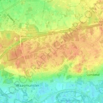
Name: Heide topographic map, elevation, terrain.
Average elevation: 62 ft
Minimum elevation: -3 ft
Maximum elevation: 108 ft
Make a donation
Gear up for your next adventure:
As an Amazon Associate, this site earns from qualifying purchases at no extra cost to you.
Other topographic maps
Click on a map to view its topography, its elevation and its terrain.
Cuesta van het Waasland te Waasmunster
België > Oost-Vlaanderen > Dendermonde > Waasmunster > Ruiter
Average elevation: 59 ft
Waasmunster
België > Oost-Vlaanderen > Dendermonde > Waasmunster
Waasmunster ligt in Zandig Vlaanderen en het Waasland. De kern ligt in de vallei van de Durme en de hoogte bedraagt 4-5 meter. Op de Cuesta van het Waasland wordt een hoogte tot 30 meter bereikt.
Average elevation: 36 ft