
Santa Marta topographic map
Click on the map to display elevation.
About this map
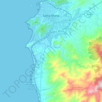
Name: Santa Marta topographic map, elevation, terrain.
Location: Santa Marta, Magdalena, RAP Caribe, Colombia (11.07829 -74.24180 11.25925 -74.13999)
Average elevation: 702 ft
Minimum elevation: -3 ft
Maximum elevation: 4,787 ft
Other topographic maps
Click on a map to view its topography, its elevation and its terrain.
Pico Cristóbal Colón
Colombia > Magdalena > Santa Marta
Pico Cristóbal Colón is possibly the highest mountain in Colombia, with a reported height of 5,775 metres (18,947 ft). Pico Cristóbal Colón and Pico Simón Bolívar are the two highest peaks in Colombia and almost equal in elevation. One of the two mountains is therefore the fifth most prominent in the…
Average elevation: 16,768 ft