Geolocate

Minca topographic map

Click on the map to display elevation.

About this map

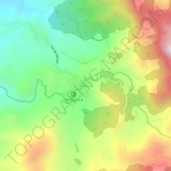
Name: Minca topographic map, elevation, terrain.

Location: Minca, Santa Marta, Magdalena, 470008, Colombia (11.12276 -74.13693 11.16276 -74.09693)

Average elevation: 2,339 ft

Minimum elevation: 896 ft

Maximum elevation: 4,354 ft

Other topographic maps

Click on a map to view its topography, its elevation and its terrain.

Santa Marta

Colombia > Magdalena > Santa Marta

Average elevation: 702 ft

Santa Marta

Colombia > Magdalena > Santa Marta

Average elevation: 702 ft

Santa Marta

Colombia > Magdalena > Santa Marta

Average elevation: 702 ft

Arrecifes Beach

Colombia > Magdalena > Santa Marta

Average elevation: 102 ft

Gear up for your next adventure:

📶Vehicle Signal Boosters - Improve reception in rural areas while driving to trailheads
🪶Paracord Bracelet - Survival bracelet with built‑in tools
🚪Portable Camp Chair - Foldable chair for comfort at camp
🪓Survival Multi‑Tool - Versatile tool for camp and trail tasks
🔭Compact Binoculars - HD vision for scouting terrain and identifying distant landmarks

As an Amazon Associate, this site earns from qualifying purchases at no extra cost to you.