
Nicolas Romero topographic map
Interactive map
Click on the map to display elevation.
About this map
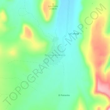
Name: Nicolas Romero topographic map, elevation, terrain.
Location: Nicolas Romero, Municipio de Durango, Durango, México (23.77168 -104.50923 23.81168 -104.46923)
Average elevation: 6,693 ft
Minimum elevation: 6,430 ft
Maximum elevation: 7,215 ft
Other topographic maps
Click on a map to view its topography, its elevation and its terrain.
Victoria de Durango
México > Durango > Municipio de Durango
Dentro del valle, a una altitud promedio de 1880 m s. n. m. solo se encuentran dos accidentes notables: El cerro de Mercado (2040 m s. n. m.) al norte de la ciudad y el cerro de los Remedios (1980 m s. n. m.) al poniente, además de varias lomas que aumentan hasta el oeste del valle para dar paso a la Sierra…
Average elevation: 6,352 ft