Geolocate

Lombok topographic map

Click on the map to display elevation.

About this map

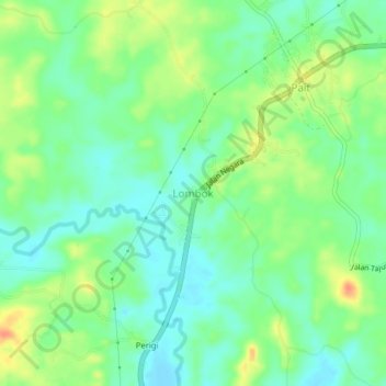
Name: Lombok topographic map, elevation, terrain.

Location: Lombok, Paser, East Kalimantan, Kalimantan, Indonesia (-1.63603 116.13634 -1.59603 116.17634)

Average elevation: 66 ft

Minimum elevation: 7 ft

Maximum elevation: 157 ft

Other topographic maps

Click on a map to view its topography, its elevation and its terrain.

Sungai Kendilo

Indonesia > East Kalimantan > Paser > Pepara

Average elevation: 16 ft

Gear up for your next adventure:

🪑Portable Camp Table - Compact table for campsite meals
🩳Quick‑Dry Hiking Shorts - Comfortable and quick‑dry shorts for summer hiking
🪶Compact Camp Shovel - Folding shovel for campsite tasks
🧯Emergency Survival Kit - All‑in‑one survival essentials for the backcountry
🔌Solar Panel Charger - Charge gear sustainably outdoors

As an Amazon Associate, this site earns from qualifying purchases at no extra cost to you.