Geolocate

Trevalyn topographic map

Click on the map to display elevation.

About this map

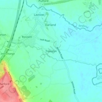
Name: Trevalyn topographic map, elevation, terrain.

Location: Trevalyn, Wrexham, Wales, LL12 0ET, United Kingdom (53.08403 -2.94909 53.12403 -2.90909)

Average elevation: 59 ft

Minimum elevation: 13 ft

Maximum elevation: 256 ft

Other topographic maps

Click on a map to view its topography, its elevation and its terrain.

Gwersyllt

United Kingdom > Wales > Wrexham

Average elevation: 367 ft

Penycae

United Kingdom > Wales > Wrexham

Average elevation: 1,148 ft

Rhosddu

United Kingdom > Wales > Wrexham

Average elevation: 289 ft

Bangor-on-Dee

United Kingdom > Wales > Wrexham

Average elevation: 98 ft

Cefn

United Kingdom > Wales > Wrexham > Acrefair

Average elevation: 466 ft

Gear up for your next adventure:

📻Weather Alert Radios - Stay informed of storm risks while off-the-grid
🥾Men's Hiking Boots - Durable, waterproof footwear for rugged terrain and steep inclines
GPS Sports Watch - GPS watch for running, hiking and training
📡Handheld GPS Device - Reliable handheld GPS for outdoor navigation
🧢Sun Protection Hats - Wide-brimmed and UPF-rated hats for high-altitude sun safety

As an Amazon Associate, this site earns from qualifying purchases at no extra cost to you.