Geolocate

Mount Chamah topographic map

Click on the map to display elevation.

About this map

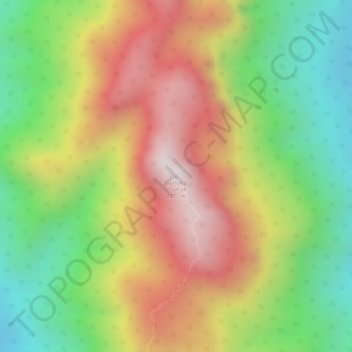
Name: Mount Chamah topographic map, elevation, terrain.

Location: Mount Chamah, Gua Musang, Kelantan, Malaysia (5.22717 101.57391 5.22727 101.57401)

Average elevation: 5,938 ft

Minimum elevation: 4,852 ft

Maximum elevation: 7,037 ft

Other topographic maps

Click on a map to view its topography, its elevation and its terrain.

Pasir Mas

Malaysia > Kelantan

Average elevation: 39 ft

Machang

Malaysia > Kelantan

Average elevation: 305 ft

Lojing

Malaysia > Kelantan

Average elevation: 2,411 ft

Sungai Long

Malaysia > Kelantan > Sungai Long

Average elevation: 1,325 ft

Pasir Puteh

Malaysia > Kelantan

Average elevation: 187 ft

Sungai Pergau

Malaysia > Kelantan

Average elevation: 1,237 ft

Tanah Merah

Malaysia > Kelantan

Average elevation: 312 ft

Sungai Jeram

Malaysia > Kelantan

Average elevation: 121 ft

Pergau Dam

Malaysia > Kelantan

Average elevation: 2,080 ft

Gear up for your next adventure:

🗺️NatGeo Topo Maps - High-quality waterproof printed topographic maps of US Parks
🚁Photography Drones - Capture stunning aerial views of landforms and topography
🧭Map Reading Tools - Tools and kits for map navigation
🔥Camping Stove - Portable stove for camping and backcountry cooking
🏕️Tent Footprint - Protect your tent base from wear

As an Amazon Associate, this site earns from qualifying purchases at no extra cost to you.