Geolocate

Lojing topographic map

Click on the map to display elevation.

About this map

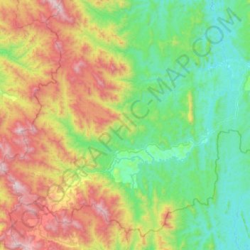
Name: Lojing topographic map, elevation, terrain.

Location: Lojing, Gua Musang, Kelantan, Malaysia (4.54631 101.33291 4.99732 101.84215)

Average elevation: 2,411 ft

Minimum elevation: 410 ft

Maximum elevation: 7,008 ft

Other topographic maps

Click on a map to view its topography, its elevation and its terrain.

Gua Musang

Malaysia > Kelantan

Average elevation: 472 ft

Mount Chamah

Malaysia > Kelantan

Average elevation: 5,938 ft

Kampung Repek

Malaysia > Kelantan

Average elevation: 16 ft

Kampung Telaga Papan

Malaysia > Kelantan

Average elevation: 20 ft

Selising

Malaysia > Kelantan

Average elevation: 39 ft

Bukit Abal

Malaysia > Kelantan

Average elevation: 39 ft

Sungai Long

Malaysia > Kelantan > Sungai Long

Average elevation: 1,325 ft

Kampung Pulau Gajah

Malaysia > Kelantan > Kota Bharu

Average elevation: 20 ft

Sungai Jeram

Malaysia > Kelantan

Average elevation: 121 ft

Gunung Yong Belar

Malaysia > Kelantan

Average elevation: 5,620 ft

Pergau Dam

Malaysia > Kelantan

Average elevation: 2,080 ft

Gear up for your next adventure:

📱Solar Portable Charger - Solar power bank for charging devices off‑grid
🔭Stargazing Telescopes - Perfect for camping in low-light pollution areas shown on maps
🪶Compact Camp Shovel - Folding shovel for campsite tasks
🚪Portable Camp Chair - Foldable chair for comfort at camp
🚗GPS Dash Cams - Record your scenic drives through mountain passes and canyons

As an Amazon Associate, this site earns from qualifying purchases at no extra cost to you.