
Make a donation
Gear up for your next adventure:
As an Amazon Associate, this site earns from qualifying purchases at no extra cost to you.
Öhningen topographic map
Click on the map to display elevation.
Make a donation
Gear up for your next adventure:
As an Amazon Associate, this site earns from qualifying purchases at no extra cost to you.
About this map
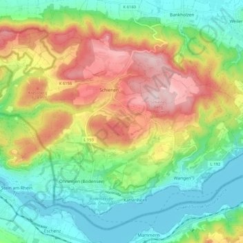
Name: Öhningen topographic map, elevation, terrain.
Average elevation: 1,706 ft
Minimum elevation: 1,283 ft
Maximum elevation: 2,372 ft
Make a donation
Gear up for your next adventure:
As an Amazon Associate, this site earns from qualifying purchases at no extra cost to you.
Other topographic maps
Click on a map to view its topography, its elevation and its terrain.
Rickelshausen
Germany > Baden-Württemberg > Landkreis Konstanz > Radolfzell am Bodensee > Böhringen
Average elevation: 1,332 ft
Make a donation
Gear up for your next adventure:
As an Amazon Associate, this site earns from qualifying purchases at no extra cost to you.
Bleiche
Germany > Baden-Württemberg > Landkreis Konstanz > Stockach > Hindelwangen
Average elevation: 1,860 ft
Alte Ölmühle
Germany > Baden-Württemberg > Landkreis Konstanz > Engen > Anselfingen
Average elevation: 1,841 ft
Make a donation
Gear up for your next adventure:
As an Amazon Associate, this site earns from qualifying purchases at no extra cost to you.