
Make a donation
Gear up for your next adventure:
As an Amazon Associate, this site earns from qualifying purchases at no extra cost to you.
Río Ypané topographic map
Click on the map to display elevation.
Make a donation
Gear up for your next adventure:
As an Amazon Associate, this site earns from qualifying purchases at no extra cost to you.
About this map
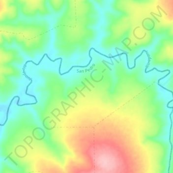
Name: Río Ypané topographic map, elevation, terrain.
Average elevation: 663 ft
Minimum elevation: 495 ft
Maximum elevation: 958 ft
Make a donation
Gear up for your next adventure:
As an Amazon Associate, this site earns from qualifying purchases at no extra cost to you.
Other topographic maps
Click on a map to view its topography, its elevation and its terrain.
Pedro Juan Caballero
Paraguay > Amambay > Pedro Juan Caballero
La ciudad de Pedro Juan Caballero se halla asentada en una meseta de la Cordillera del Amambay, a unos 700 metros sobre el nivel del mar. La topografía del terreno se presenta sin accidentes considerables, presentando un aspecto agradable con suaves ondulaciones.
Average elevation: 1,827 ft