Geolocate

Mount Gravatt topographic map

Click on the map to display elevation.

About this map

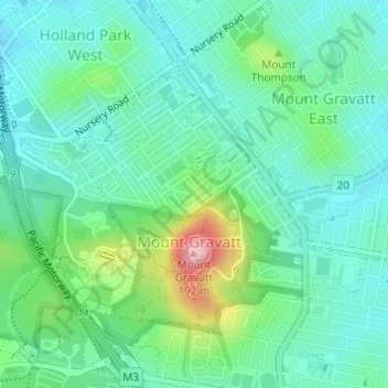
Name: Mount Gravatt topographic map, elevation, terrain.

Location: Mount Gravatt, City of Brisbane, Queensland, Australia (-27.54823 153.05832 -27.52897 153.08613)

Average elevation: 223 ft

Minimum elevation: 89 ft

Maximum elevation: 617 ft

Other topographic maps

Click on a map to view its topography, its elevation and its terrain.

Enoggera Hill

Australia > Queensland > City of Brisbane

Average elevation: 374 ft

Toohey Mountain

Australia > Queensland > City of Brisbane

Average elevation: 174 ft

Blunder Creek

Australia > Queensland > City of Brisbane

Average elevation: 85 ft

Tangalooma

Australia > Queensland > City of Brisbane

Average elevation: 135 ft

Timberland Park

Australia > Queensland > City of Brisbane

Average elevation: 121 ft

Deepwater Bend

Australia > Queensland > City of Brisbane

Average elevation: 16 ft

Tangalooma

Australia > Queensland > City of Brisbane

Average elevation: 135 ft

Gear up for your next adventure:

📖Nature Tracking Books - Learn to track wildlife and terrain
🧦Merino Wool Socks - Moisture-wicking, blister-preventing socks for long treks
🪄Magnetic Compass - Accurate compass for navigation
🎒Trekking Poles - Sturdy poles for balance and stability on rough terrain
🧭Map Reading Tools - Tools and kits for map navigation

As an Amazon Associate, this site earns from qualifying purchases at no extra cost to you.