
Make a donation
Gear up for your next adventure:
As an Amazon Associate, this site earns from qualifying purchases at no extra cost to you.
Steep Hill topographic map
Click on the map to display elevation.
Make a donation
Gear up for your next adventure:
As an Amazon Associate, this site earns from qualifying purchases at no extra cost to you.
About this map
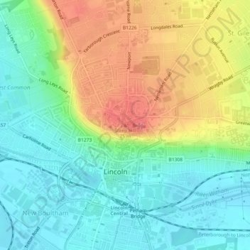
Name: Steep Hill topographic map, elevation, terrain.
Average elevation: 105 ft
Minimum elevation: 10 ft
Maximum elevation: 253 ft
Make a donation
Gear up for your next adventure:
As an Amazon Associate, this site earns from qualifying purchases at no extra cost to you.
Other topographic maps
Click on a map to view its topography, its elevation and its terrain.
Brayford Pool
United Kingdom > England > Lincolnshire > Lincoln > Bracebridge
Average elevation: 66 ft
Skellingthorpe Moor Plantation
United Kingdom > England > Lincolnshire > Lincoln
Average elevation: 56 ft
Make a donation
Gear up for your next adventure:
As an Amazon Associate, this site earns from qualifying purchases at no extra cost to you.