
Make a donation
Gear up for your next adventure:
As an Amazon Associate, this site earns from qualifying purchases at no extra cost to you.
Marksburg topographic map
Click on the map to display elevation.
Make a donation
Gear up for your next adventure:
As an Amazon Associate, this site earns from qualifying purchases at no extra cost to you.
Marksburg
Die Marksburg ist eine aus dem 12. Jahrhundert stammende Höhenburg oberhalb der rheinland-pfälzischen Stadt Braubach am Rhein, von der sie ihren ursprünglichen Namen Burg Brubach bezog. Sie steht auf einem Schieferkegel in 160 Meter Höhe und ist die einzige nie zerstörte mittelalterliche Höhenburg am Mittelrhein. Der verputzte Bruchsteinbau entstand zum Schutz und zur Verwaltung Braubachs und diente anfänglich auch als Zollburg.
Make a donation
Gear up for your next adventure:
As an Amazon Associate, this site earns from qualifying purchases at no extra cost to you.
About this map
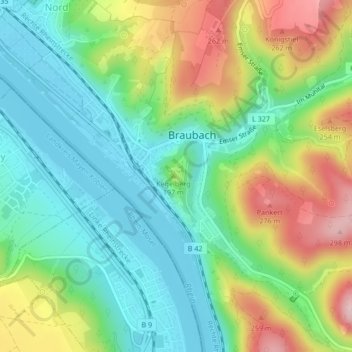
Name: Marksburg topographic map, elevation, terrain.
Average elevation: 486 ft
Minimum elevation: 213 ft
Maximum elevation: 978 ft
Make a donation
Gear up for your next adventure:
As an Amazon Associate, this site earns from qualifying purchases at no extra cost to you.
Other topographic maps
Click on a map to view its topography, its elevation and its terrain.