Geolocate

Oronoco topographic map

Click on the map to display elevation.

About this map

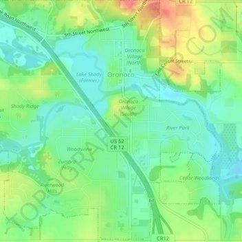
Name: Oronoco topographic map, elevation, terrain.

Location: Oronoco, Olmsted County, Minnesota, United States (44.14430 -92.55823 44.17314 -92.51835)

Average elevation: 1,001 ft

Minimum elevation: 925 ft

Maximum elevation: 1,125 ft

Olmsted County trails, hiking, mountain biking, running and outdoor activities

Other topographic maps

Click on a map to view its topography, its elevation and its terrain.

Essex Park

United States > Minnesota > Olmsted County > Rochester

Average elevation: 1,007 ft

Mayo Lake

United States > Minnesota > Olmsted County > Rochester

Average elevation: 1,102 ft

Gear up for your next adventure:

🦺Reflective Outdoor Gear - Safety gear for low‑light conditions
🔦Compact Flashlight - Reliable flashlight for emergencies
🪄Magnetic Compass - Accurate compass for navigation
🎒Outdoor Daypacks - Lightweight backpacks designed for carrying maps and essential gear
📶Vehicle Signal Boosters - Improve reception in rural areas while driving to trailheads

As an Amazon Associate, this site earns from qualifying purchases at no extra cost to you.