Geolocate

Voronezh topographic map

Click on the map to display elevation.

About this map
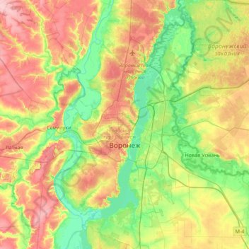
Name: Voronezh topographic map, elevation, terrain.

Location: Voronezh, Voronezh Oblast, Central Federal District, Russia (51.48487 39.01323 51.90277 39.65895)

Average elevation: 430 ft

Minimum elevation: 269 ft

Maximum elevation: 676 ft

Gear up for your next adventure:

🧯Portable Fire Pit - Compact fire pit for camping spots
🏔️Mountain Trail Maps - High‑detail maps for popular peaks
🛡️Bear Spray Outdoor - Protection in bear country hikes
⛑️Personal Locator Beacon - Safety beacon for emergencies
🪶Compact Camp Shovel - Folding shovel for campsite tasks

As an Amazon Associate, this site earns from qualifying purchases at no extra cost to you.