
Skye topographic map
Interactive map
Click on the map to display elevation.
About this map
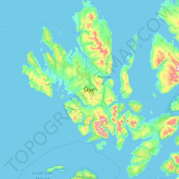
Name: Skye topographic map, elevation, terrain.
Location: Skye, Highland, Escocia, Gran Bretaña (57.01782 -6.78982 57.70821 -5.64713)
Average elevation: 207 ft
Minimum elevation: 0 ft
Maximum elevation: 3,012 ft
Other topographic maps
Click on a map to view its topography, its elevation and its terrain.
Edimburgo
Gran Bretaña > Escocia > Edimburgo
Edimburgo, City of Edinburgh, Escocia, EH1 3EG, Gran Bretaña
Average elevation: 341 ft
Aberdeen
Gran Bretaña > Escocia > Aberdeen
Aberdeen, Aberdeen City, Escocia, AB11 5EQ, Gran Bretaña
Average elevation: 171 ft
Milngavie
Gran Bretaña > Escocia > Milngavie
Milngavie, East Dunbartonshire, Escocia, G62 6BH, Gran Bretaña
Average elevation: 325 ft
Newmains
Gran Bretaña > Escocia > Newmains
Newmains, North Lanarkshire, Escocia, ML2 9EY, Gran Bretaña
Average elevation: 535 ft
Peebles
Gran Bretaña > Escocia > Peebles
Peebles, Scottish Borders, Escocia, EH45 8SL, Gran Bretaña
Average elevation: 902 ft
Argyll and Bute
Argyll and Bute, Escocia, Gran Bretaña
Average elevation: 276 ft