
Make a donation
Gear up for your next adventure:
As an Amazon Associate, this site earns from qualifying purchases at no extra cost to you.
Andahuaylas topographic map
Click on the map to display elevation.
Make a donation
Gear up for your next adventure:
As an Amazon Associate, this site earns from qualifying purchases at no extra cost to you.
About this map
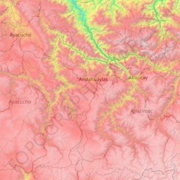
Name: Andahuaylas topographic map, elevation, terrain.
Location: Andahuaylas, Apurímac, Peru (-14.77769 -74.42854 -12.77769 -72.42854)
Average elevation: 11,926 ft
Minimum elevation: 2,156 ft
Maximum elevation: 19,800 ft
Make a donation
Gear up for your next adventure:
As an Amazon Associate, this site earns from qualifying purchases at no extra cost to you.
Other topographic maps
Click on a map to view its topography, its elevation and its terrain.
Curahuasi
Der Distrikt Curahuasi liegt in der Provinz Abancay in der Region Apurímac in Zentral-Peru. Der Distrikt wurde am 2. Januar 1857 gegründet. Er hat eine Fläche von 857 km². Beim Zensus 2017 lebten 17.065 Einwohner im Distrikt. Im Jahr 1993 lag die Einwohnerzahl bei 16.137, im Jahr 2007 bei 16.532. Die…
Average elevation: 11,493 ft