Geolocate

Radhanpur topographic map

Click on the map to display elevation.

Radhanpur

Radhanpur is located at 23°50′N 71°36′E / 23.83°N 71.6°E / 23.83; 71.6. It has an average elevation of 27 metres (88 feet).

Wikipedia (CC-BY-SA 3.0)

About this map

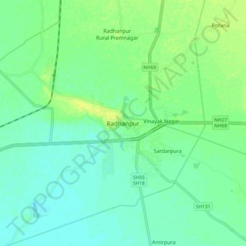
Name: Radhanpur topographic map, elevation, terrain.

Location: Radhanpur, Radhanpur Taluka, Patan District, Gujarat, 385340, India (23.79157 71.57039 23.87157 71.65039)

Average elevation: 98 ft

Minimum elevation: 75 ft

Maximum elevation: 135 ft

Gear up for your next adventure:

🪶Paracord Bracelet - Survival bracelet with built‑in tools
🧼Biodegradable Camping Soap - Eco‑friendly soap for outdoor hygiene
🪶Multi‑Purpose Knife - Useful blade for camp and trail
🌡️Handheld Weather Meters - Measure wind, temp, and pressure for safe mountain travel
🍳Camping Cook Set - Complete cookware for outdoor meals

As an Amazon Associate, this site earns from qualifying purchases at no extra cost to you.