Geolocate

Broadlands topographic map

Click on the map to display elevation.

About this map

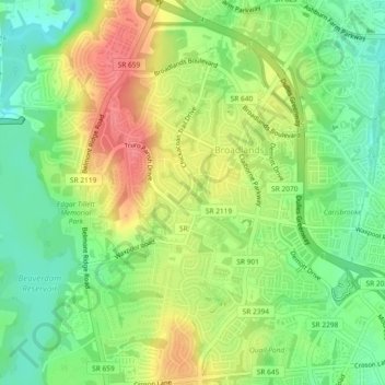
Name: Broadlands topographic map, elevation, terrain.

Location: Broadlands, Loudoun County, Virginia, United States (39.00134 -77.53218 39.03715 -77.49639)

Average elevation: 338 ft

Minimum elevation: 226 ft

Maximum elevation: 472 ft

Loudoun County trails, hiking, mountain biking, running and outdoor activities

Gear up for your next adventure:

💧Water Purification System - Clean water on the trail with reliable purifiers
🎒Trekking Poles - Sturdy poles for balance and stability on rough terrain
🪓Survival Multi‑Tool - Versatile tool for camp and trail tasks
🛡️Insect Repellent - Protection against bugs during outdoor activities
🧭Hiking Compass - Precision compass for reliable navigation in the wilderness

As an Amazon Associate, this site earns from qualifying purchases at no extra cost to you.