Geolocate

Dipaculao topographic map

Click on the map to display elevation.

About this map

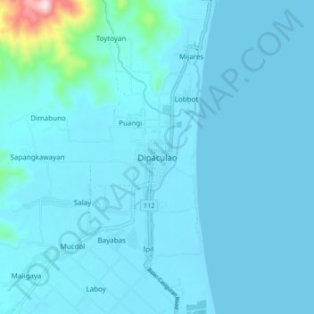
Name: Dipaculao topographic map, elevation, terrain.

Location: Dipaculao, Aurora, Central Luzon, 3203, Philippines (15.80838 121.49676 15.88838 121.57676)

Average elevation: 115 ft

Minimum elevation: -7 ft

Maximum elevation: 1,923 ft

Other topographic maps

Click on a map to view its topography, its elevation and its terrain.

Baler

Philippines > Aurora

Average elevation: 338 ft

Dingalan

Philippines > Aurora

Average elevation: 817 ft

Dicasalarin Cove

Philippines > Aurora > Baler

Average elevation: 253 ft

Dingalan River

Philippines > Aurora > Dingalan

Average elevation: 617 ft

Aguang River

Philippines > Aurora > Baler

Average elevation: 118 ft

Quezon Memorial Park

Philippines > Aurora > Baler > Sabang

Average elevation: 20 ft

Umiray River

Philippines > Aurora > Dingalan > Abungan

Average elevation: 305 ft

Casapsapan Beach

Philippines > Aurora > Casiguran > Dipasaleng

Average elevation: 72 ft

Dingalan

Philippines > Aurora

Average elevation: 817 ft

Dingalan

Philippines > Aurora

Average elevation: 817 ft

Dingalan

Philippines > Aurora

Average elevation: 817 ft

Baler

Philippines > Aurora

Average elevation: 200 ft

Gear up for your next adventure:

Solar GPS Watches - Advanced multisport watches with built-in topographic maps
🧥Men's Rain Shells - Premium waterproof and breathable jackets for mountain weather
🛌Ultralight Sleeping Bags - Compact down bags for cold nights in the wilderness
🎒Trail Energy Bars - High‑calorie bars for hiking energy
🌧️Backpack Rain Cover - Keep gear dry in wet weather

As an Amazon Associate, this site earns from qualifying purchases at no extra cost to you.