
Thank you for supporting this site ❤️
Make a donation
Make a donation
Gear up for your next adventure:
As an Amazon Associate, this site earns from qualifying purchases at no extra cost to you.
Schioppi topographic map
Click on the map to display elevation.
Thank you for supporting this site ❤️
Make a donation
Make a donation
Gear up for your next adventure:
As an Amazon Associate, this site earns from qualifying purchases at no extra cost to you.
About this map
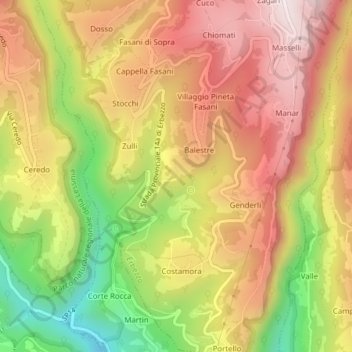
Name: Schioppi topographic map, elevation, terrain.
Location: Schioppi, Véderle, Erbezzo, Verona, Veneto, 37020, Italia (45.60993 10.97935 45.62993 10.99935)
Average elevation: 2,579 ft
Minimum elevation: 1,499 ft
Maximum elevation: 3,422 ft
Thank you for supporting this site ❤️
Make a donation
Make a donation
Gear up for your next adventure:
As an Amazon Associate, this site earns from qualifying purchases at no extra cost to you.