Geolocate

Dewitt topographic map

Click on the map to display elevation.

About this map

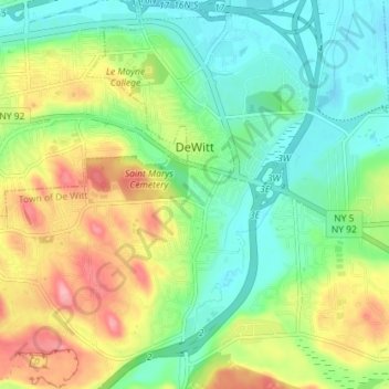
Name: Dewitt topographic map, elevation, terrain.

Location: Dewitt, Onondaga County, New York, United States (43.01022 -76.13433 43.05437 -76.06280)

Average elevation: 538 ft

Minimum elevation: 400 ft

Maximum elevation: 771 ft

New York trails, hiking, mountain biking, running and outdoor activities

Gear up for your next adventure:

🔋Solar Power Banks - Keep your GPS and phone charged in remote wilderness areas
🌡️Handheld Weather Meters - Measure wind, temp, and pressure for safe mountain travel
🔌USB Car Charger - Car charger for on‑the‑go power needs
🥾Men's Hiking Boots - Durable, waterproof footwear for rugged terrain and steep inclines
🥾Women's Hiking Boots - Top-rated trail boots with ankle support and superior grip

As an Amazon Associate, this site earns from qualifying purchases at no extra cost to you.