
Make a donation
Gear up for your next adventure:
As an Amazon Associate, this site earns from qualifying purchases at no extra cost to you.
Nathdwara topographic map
Click on the map to display elevation.
Make a donation
Gear up for your next adventure:
As an Amazon Associate, this site earns from qualifying purchases at no extra cost to you.
Nathdwara
Nathdwara is located at 24°56′N 73°49′E / 24.93°N 73.82°E / 24.93; 73.82. It has an average elevation of 584 metres (1919 ft). Located just 48 km north-east of Udaipur in Rajasthan, this town is easily reached by air, road or nearest rail-head.
Make a donation
Gear up for your next adventure:
As an Amazon Associate, this site earns from qualifying purchases at no extra cost to you.
About this map
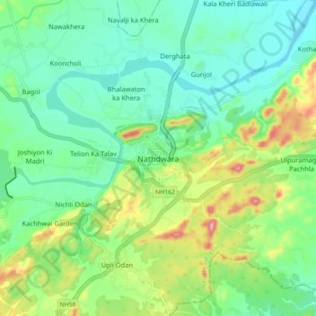
Name: Nathdwara topographic map, elevation, terrain.
Average elevation: 1,936 ft
Minimum elevation: 1,765 ft
Maximum elevation: 2,339 ft
Make a donation
Gear up for your next adventure:
As an Amazon Associate, this site earns from qualifying purchases at no extra cost to you.