
Make a donation
Gear up for your next adventure:
As an Amazon Associate, this site earns from qualifying purchases at no extra cost to you.
Chipata topographic map
Click on the map to display elevation.
Make a donation
Gear up for your next adventure:
As an Amazon Associate, this site earns from qualifying purchases at no extra cost to you.
Chipata
Chipata is located approximately 570 kilometres (354 mi) east of Lusaka, the capital city of Zambia. This is about 150 kilometres (93 mi) west of Lilongwe, the capital city of Malawi. The geographical coordinates of Chipata are 13°38'43.0"S, 32°38'47.0"E (Latitude:13°38'43.0"S; Longitude:32°38'47.0"E). The average elevation of Chipata is 1,181 metres (3,875 ft), above sea level.
Make a donation
Gear up for your next adventure:
As an Amazon Associate, this site earns from qualifying purchases at no extra cost to you.
About this map
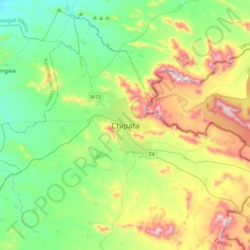
Name: Chipata topographic map, elevation, terrain.
Location: Chipata, Chipata District, Eastern Province, Zambia (-13.79913 32.48584 -13.47913 32.80584)
Average elevation: 3,717 ft
Minimum elevation: 2,894 ft
Maximum elevation: 5,472 ft
Make a donation
Gear up for your next adventure:
As an Amazon Associate, this site earns from qualifying purchases at no extra cost to you.
Other topographic maps
Click on a map to view its topography, its elevation and its terrain.