Geolocate

Hachum topographic map

Click on the map to display elevation.

About this map

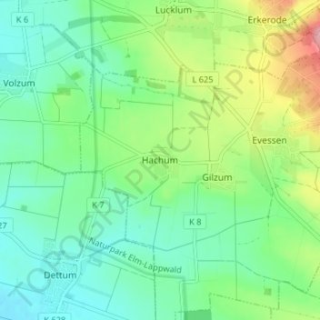
Name: Hachum topographic map, elevation, terrain.

Location: Hachum, Evessen, Samtgemeinde Sickte, Landkreis Wolfenbüttel, Lower Saxony, 38173, Germany (52.16618 10.66650 52.20618 10.70650)

Average elevation: 417 ft

Minimum elevation: 285 ft

Maximum elevation: 728 ft

Other topographic maps

Click on a map to view its topography, its elevation and its terrain.

Erkerode

Germany > Lower Saxony > Landkreis Wolfenbüttel

Average elevation: 584 ft

Wolfenbüttel

Germany > Lower Saxony > Landkreis Wolfenbüttel

The town center is located at an elevation of 77 ft (23 m) on the Oker river near the confluence with its Altenau tributary, about 13 km (8.1 mi) south of Brunswick and 60 km (37 mi) southeast of the state capital Hannover. Wolfenbüttel is situated about half-way between the Harz mountain range in the south…

Average elevation: 325 ft

Veltheim

Germany > Lower Saxony > Landkreis Wolfenbüttel

Average elevation: 433 ft

Gear up for your next adventure:

🪶Compact Camp Shovel - Folding shovel for campsite tasks
🪶Camping Sleeping Pad - Comfortable sleeping pad for backpacking
🧷Carabiner Set - Durable clips for gear attachment
🛶Inflatable Kayak - Portable kayak for rivers, lakes, and expeditions
🧺Microfiber Travel Towels - Compact and fast-drying towels for trail use

As an Amazon Associate, this site earns from qualifying purchases at no extra cost to you.