Geolocate

Huari topographic map

Click on the map to display elevation.

About this map

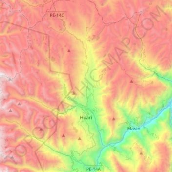
Name: Huari topographic map, elevation, terrain.

Location: Huari, Provincia de Huari, Áncash, Perú (-9.43306 -77.33456 -9.16521 -77.14081)

Average elevation: 12,982 ft

Minimum elevation: 7,927 ft

Maximum elevation: 17,224 ft

Other topographic maps

Click on a map to view its topography, its elevation and its terrain.

Huamparan

Perú > Áncash > Huari

Average elevation: 12,172 ft

Mallas

Perú > Áncash > Huari

Average elevation: 10,942 ft

Gear up for your next adventure:

🧤Tactile Hiking Gloves - Keep hands warm while operating GPS and smartphone screens
🔦Compact Flashlight - Reliable flashlight for emergencies
📷Action Camera - Capture your outdoor adventures in HD
⛑️Personal Locator Beacon - Safety beacon for emergencies
❄️Traction Cleats - Prevent slips on icy trails during winter hikes

As an Amazon Associate, this site earns from qualifying purchases at no extra cost to you.