
Make a donation
Gear up for your next adventure:
As an Amazon Associate, this site earns from qualifying purchases at no extra cost to you.
Glimmen topographic map
Click on the map to display elevation.
Make a donation
Gear up for your next adventure:
As an Amazon Associate, this site earns from qualifying purchases at no extra cost to you.
About this map
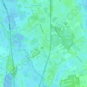
Name: Glimmen topographic map, elevation, terrain.
Location: Glimmen, Groningen, Nederland (53.11939 6.60829 53.15092 6.65022)
Average elevation: 10 ft
Minimum elevation: -13 ft
Maximum elevation: 26 ft
Make a donation
Gear up for your next adventure:
As an Amazon Associate, this site earns from qualifying purchases at no extra cost to you.
Other topographic maps
Click on a map to view its topography, its elevation and its terrain.
Make a donation
Gear up for your next adventure:
As an Amazon Associate, this site earns from qualifying purchases at no extra cost to you.
Jipsinghuizen
Nederland > Groningen > Sellingen > Jipsinghuizen
In 1915 kreeg Jipsinghuizen een station aan de stoomtramlijn Winschoten - Ter Apel van de OG. De lijn werd in 1948 opgeheven, maar het station is anno 2006 nog aanwezig op de hoek Weenderstraat-Wollinghuizerweg. Een kilometer ten zuidoosten van Jipsinghuizen ligt de Jipsinghuizersluis in het Ruiten-Aa-kanaal.…
Average elevation: 20 ft
Make a donation
Gear up for your next adventure:
As an Amazon Associate, this site earns from qualifying purchases at no extra cost to you.