
Kumisi topographic map
Click on the map to display elevation.
About this map
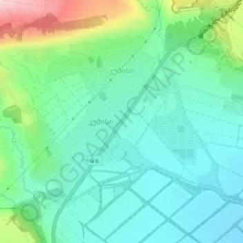
Name: Kumisi topographic map, elevation, terrain.
Location: Kumisi, Gardabani Municipality, Lower Kartli, Georgia (41.60291 44.77404 41.62256 44.79444)
Average elevation: 1,926 ft
Minimum elevation: 1,647 ft
Maximum elevation: 2,730 ft
Other topographic maps
Click on a map to view its topography, its elevation and its terrain.
Gardabani
Georgia > Lower Kartli > Gardabani Municipality
Gardabani (Georgian: გარდაბანი) is a city of 11,650 residents (2021) in the valley or plain of the same name, in the southern Georgian region of Kvemo Kartli and is the administrative centre of the Gardabani Municipality. It is located 34 kilometres (21 mi) southeast of capital Tbilisi and 10…
Average elevation: 981 ft