
Thank you for supporting this site ❤️
Make a donation
Make a donation
Gear up for your next adventure:
As an Amazon Associate, this site earns from qualifying purchases at no extra cost to you.
Puemba topographic map
Click on the map to display elevation.
Thank you for supporting this site ❤️
Make a donation
Make a donation
Gear up for your next adventure:
As an Amazon Associate, this site earns from qualifying purchases at no extra cost to you.
About this map
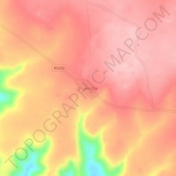
Name: Puemba topographic map, elevation, terrain.
Location: Puemba, Plateaux, Mai-Ndombe, Democratic Republic of the Congo (-3.22910 16.29714 -3.18910 16.33714)
Average elevation: 1,526 ft
Minimum elevation: 1,079 ft
Maximum elevation: 1,680 ft
Thank you for supporting this site ❤️
Make a donation
Make a donation
Gear up for your next adventure:
As an Amazon Associate, this site earns from qualifying purchases at no extra cost to you.