Geolocate

Pancian topographic map

Click on the map to display elevation.

About this map

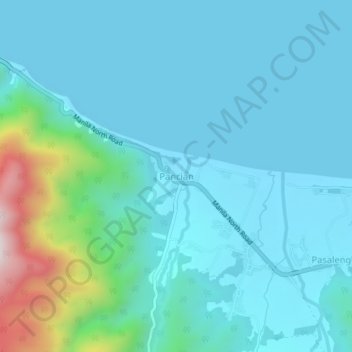
Name: Pancian topographic map, elevation, terrain.

Location: Pancian, Pagudpud, Ilocos Norte, Ilocos Region, Philippines (18.53867 120.89885 18.57867 120.93885)

Average elevation: 354 ft

Minimum elevation: -7 ft

Maximum elevation: 2,411 ft

Other topographic maps

Click on a map to view its topography, its elevation and its terrain.

Saud Beach

Philippines > Ilocos Norte > Pagudpud > Saud

Average elevation: 36 ft

Saud Beach

Philippines > Ilocos Norte > Pagudpud > Saud

Average elevation: 36 ft

Gear up for your next adventure:

😴Insulated Sleeping Pads - Compact and warm pads for high-elevation camping
🪶Camp Gear Gift Set - Perfect gift bundle for outdoor fans
🎒Hydration Pack - Hands‑free water reservoir for long hikes
🗺️NatGeo Topo Maps - High-quality waterproof printed topographic maps of US Parks
🎒Waterproof Dry Bags - Keep your electronics and maps dry inside your pack

As an Amazon Associate, this site earns from qualifying purchases at no extra cost to you.