Geolocate

Hayden topographic map

Click on the map to display elevation.

About this map

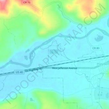
Name: Hayden topographic map, elevation, terrain.

Location: Hayden, Routt County, Colorado, United States (40.49505 -107.27672 40.49949 -107.26968)

Average elevation: 6,404 ft

Minimum elevation: 6,312 ft

Maximum elevation: 6,752 ft

Routt County trails, hiking, mountain biking, running and outdoor activities

Other topographic maps

Click on a map to view its topography, its elevation and its terrain.

Pagoda

United States > Colorado > Routt County

Average elevation: 6,850 ft

Oak Creek

United States > Colorado > Routt County

Average elevation: 7,628 ft

Hahns Peak

United States > Colorado > Routt County

Average elevation: 9,482 ft

Steamboat Lake

United States > Colorado > Routt County

Average elevation: 8,084 ft

Sugar Loaf Mountain

United States > Colorado > Routt County

Average elevation: 9,186 ft

Gore Mountain

United States > Colorado > Routt County

Average elevation: 10,180 ft

Gear up for your next adventure:

🧼Biodegradable Camping Soap - Eco‑friendly soap for outdoor hygiene
Solar GPS Watches - Advanced multisport watches with built-in topographic maps
🧦Hiking Socks - Comfortable socks to prevent blisters on long hikes
🔥Fast-Boil Camping Stoves - Efficient cooking systems for quick trail meals
👟Trail Running Shoes - Lightweight shoes for trail runners

As an Amazon Associate, this site earns from qualifying purchases at no extra cost to you.