
Kala Patthar topographic map
Interactive map
Click on the map to display elevation.
About this map
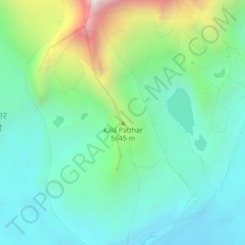
Name: Kala Patthar topographic map, elevation, terrain.
Average elevation: 17,828 ft
Minimum elevation: 16,841 ft
Maximum elevation: 20,620 ft
The elevation is commonly listed as 5,545–5,550 m (18,192–18,209 ft). One source lists the height as 5,600 meters/18,373 feet. Portland State University Assistant Professor Dr. Luis A. Ruedas took a Garmin eMap GPS unit to the summit on 6 December 2006. These units have the capability to average a series of individual satellite readings, making them more accurate than single reading machines. Averaging 48 readings at 0625h Nepal local time, temperature −20 °C, the GPS recorded the location of the summit as 27°59.750'N, 86°49.705'E (datum: WGS84), and elevation as 5,643 m (18,514 ft). Even accounting for the fact that the summit may have approximately one meter of stones added as a celebratory cairn, this is a significant discrepancy with previously recorded elevations. The same unit was consistent with respect to previously recorded elevations for Gorak Shep and Everest Base Camp. In October 2008, a GPS with WAAS recorded the summit at 27°59.751'N, 86°49.705'E (datum: WGS84) with an elevation of 5,644.5 m (18,519 ft), confirming the 2006 data.
Other topographic maps
Click on a map to view its topography, its elevation and its terrain.
Ama Dablam
Nepal > Solukhumbu > Khumjung
Ama Dablam, Khumjung, Khumbupasanglahmu, Solukhumbu, Province #1, Nepal
Average elevation: 18,455 ft