
仁兴镇 topographic map
Interactive map
Click on the map to display elevation.
About this map
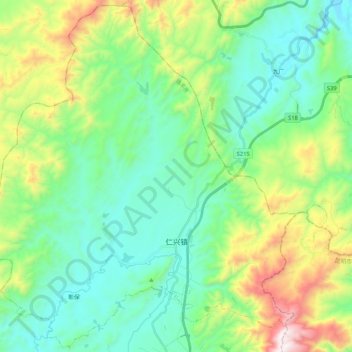
Name: 仁兴镇 topographic map, elevation, terrain.
Location: 仁兴镇, 禄丰市, 楚雄彝族自治州, 云南省, 中国 (25.32004 102.17813 25.50406 102.38754)
Average elevation: 6,552 ft
Minimum elevation: 5,643 ft
Maximum elevation: 9,006 ft
Other topographic maps
Click on a map to view its topography, its elevation and its terrain.