
Eagle Creek Park topographic map
Interactive map
Click on the map to display elevation.
About this map
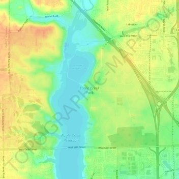
Name: Eagle Creek Park topographic map, elevation, terrain.
Average elevation: 840 ft
Minimum elevation: 778 ft
Maximum elevation: 899 ft
Other topographic maps
Click on a map to view its topography, its elevation and its terrain.
Fort Harrison State Park
United States > Indiana > Marion County > Indianapolis
Fort Harrison State Park, Indianapolis, Marion County, Indiana, United States
Average elevation: 823 ft
West Newton
United States > Indiana > Marion County > Indianapolis
West Newton, Indianapolis, Marion County, Indiana, 46183, United States
Average elevation: 748 ft
White River
United States > Indiana > Marion County > Indianapolis > Ravenswood
White River, Ravenswood, Indianapolis, Marion County, Indiana, 46240, United States
Average elevation: 745 ft
Wellington
United States > Indiana > Marion County > Indianapolis
Wellington, Indianapolis, Marion County, Indiana, 46220, United States
Average elevation: 751 ft
Maple Ridge
United States > Indiana > Marion County > Indianapolis
Maple Ridge, Indianapolis, Marion County, Indiana, 46183, United States
Average elevation: 768 ft
New Bethel
United States > Indiana > Marion County > Indianapolis
New Bethel, Indianapolis, Marion County, Indiana, 44623, United States
Average elevation: 843 ft
Legendary Hills
United States > Indiana > Marion County > Indianapolis
Legendary Hills, Indianapolis, Marion County, Indiana, 46278, United States
Average elevation: 846 ft
Drexel Gardens
United States > Indiana > Marion County > Indianapolis
Drexel Gardens, Indianapolis, Marion County, Indiana, 46241, United States
Average elevation: 741 ft
Lindenwood
United States > Indiana > Marion County > Indianapolis
Lindenwood, Indianapolis, Marion County, Indiana, 46217, United States
Average elevation: 745 ft
Sterling Heights
United States > Indiana > Marion County > Indianapolis > Sterling Heights
Sterling Heights, Indianapolis, Marion County, Indiana, 46251, United States
Average elevation: 781 ft
Glendale Heights
United States > Indiana > Marion County > Indianapolis
Glendale Heights, Indianapolis, Marion County, Indiana, 46220, United States
Average elevation: 751 ft
Newfields
United States > Indiana > Marion County > Indianapolis > Shooters Hill
Newfields, Shooters Hill, Indianapolis, Marion County, Indiana, 46208, United States
Average elevation: 741 ft