
Make a donation
Gear up for your next adventure:
As an Amazon Associate, this site earns from qualifying purchases at no extra cost to you.
Maple Ridge topographic map
Click on the map to display elevation.
Make a donation
Gear up for your next adventure:
As an Amazon Associate, this site earns from qualifying purchases at no extra cost to you.
About this map
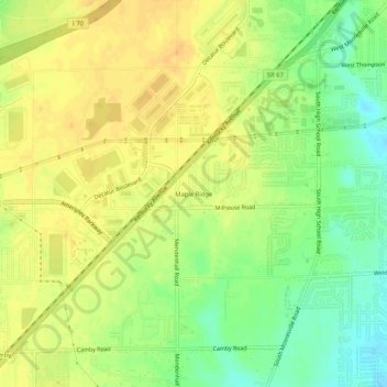
Name: Maple Ridge topographic map, elevation, terrain.
Average elevation: 768 ft
Minimum elevation: 705 ft
Maximum elevation: 810 ft
Marion County trails, hiking, mountain biking, running and outdoor activities
Make a donation
Gear up for your next adventure:
As an Amazon Associate, this site earns from qualifying purchases at no extra cost to you.
Other topographic maps
Click on a map to view its topography, its elevation and its terrain.
Fort Harrison State Park
United States > Indiana > Marion County > Indianapolis
Average elevation: 823 ft
White River
United States > Indiana > Marion County > Indianapolis > Ravenswood
Average elevation: 745 ft
Dawson Lake
United States > Indiana > Marion County > Indianapolis > Shore Acres
Average elevation: 738 ft