
Make a donation
Gear up for your next adventure:
As an Amazon Associate, this site earns from qualifying purchases at no extra cost to you.
Spytkowice topographic map
Click on the map to display elevation.
Make a donation
Gear up for your next adventure:
As an Amazon Associate, this site earns from qualifying purchases at no extra cost to you.
About this map
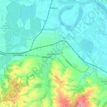
Name: Spytkowice topographic map, elevation, terrain.
Average elevation: 791 ft
Minimum elevation: 699 ft
Maximum elevation: 1,086 ft
Make a donation
Gear up for your next adventure:
As an Amazon Associate, this site earns from qualifying purchases at no extra cost to you.
Other topographic maps
Click on a map to view its topography, its elevation and its terrain.
Dąbry
Poland > Lesser Poland Voivodeship > Wadowice County > Stanisław Górny
Average elevation: 1,122 ft
Make a donation
Gear up for your next adventure:
As an Amazon Associate, this site earns from qualifying purchases at no extra cost to you.
Bochenkowa Dolina
Poland > Lesser Poland Voivodeship > Wadowice County > Skawce
Average elevation: 1,175 ft