
Chesterfield topographic map
Click on the map to display elevation.
About this map
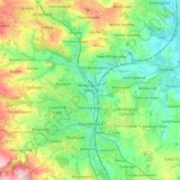
Name: Chesterfield topographic map, elevation, terrain.
Location: Chesterfield, Derbyshire, England, United Kingdom (53.21242 -1.48429 53.29903 -1.30130)
Average elevation: 417 ft
Minimum elevation: 135 ft
Maximum elevation: 1,001 ft
Other topographic maps
Click on a map to view its topography, its elevation and its terrain.
Sawmills
United Kingdom > England > Derbyshire > Amber Valley > Ripley > Fritchley
Average elevation: 390 ft