Geolocate

269M topographic map

Click on the map to display elevation.

About this map

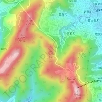
Name: 269M topographic map, elevation, terrain.

Location: 269M, Nagasaki, Nagasaki Prefecture, 850-8685, Japan (32.76395 129.84097 32.76405 129.84107)

Average elevation: 469 ft

Minimum elevation: 30 ft

Maximum elevation: 1,043 ft

Other topographic maps

Click on a map to view its topography, its elevation and its terrain.

木場公園

Japan > Nagasaki

Average elevation: 689 ft

Gear up for your next adventure:

🕶️GPS Smartphone Mount - Secure mount for phone navigation
📚USA Hiking Guide Books - Top trail guides and map books
☀️Outdoor Sunscreen - High protection sunscreen for outdoor activities
🛰️Satellite Messengers - Emergency SOS and two-way messaging for off-grid adventures
🪶Survival Guide Book - Expert advice for emergency preparedness

As an Amazon Associate, this site earns from qualifying purchases at no extra cost to you.