
Make a donation
Gear up for your next adventure:
As an Amazon Associate, this site earns from qualifying purchases at no extra cost to you.
Ñuble Region topographic map
Click on the map to display elevation.
Make a donation
Gear up for your next adventure:
As an Amazon Associate, this site earns from qualifying purchases at no extra cost to you.
About this map
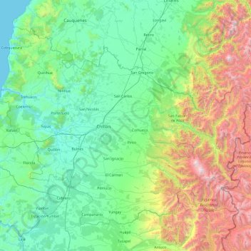
Name: Ñuble Region topographic map, elevation, terrain.
Location: Ñuble Region, Chile (-37.19718 -72.88578 -36.00537 -71.00683)
Average elevation: 2,051 ft
Minimum elevation: 0 ft
Maximum elevation: 10,367 ft
Make a donation
Gear up for your next adventure:
As an Amazon Associate, this site earns from qualifying purchases at no extra cost to you.
Other topographic maps
Click on a map to view its topography, its elevation and its terrain.
Villa O'Higgins
Chile > Aysén Region > Provincia de Capitán Prat > O’Higgins
Average elevation: 1,319 ft
Parque Rio Colina Norte
Chile > Santiago Metropolitan Region > Provincia de Chacabuco > Colina
Average elevation: 2,205 ft
Make a donation
Gear up for your next adventure:
As an Amazon Associate, this site earns from qualifying purchases at no extra cost to you.
Cerro Cazador
Chile > Region of Magallanes and Chilean Antarctica > Provincia de Última Esperanza > Torres del Paine
Average elevation: 2,703 ft
Cape Horn
Chile > Magallanes and Chilean Antarctica Region > Provincia de la Antártica Chilena > Cape Horn
Average elevation: 131 ft
Make a donation
Gear up for your next adventure:
As an Amazon Associate, this site earns from qualifying purchases at no extra cost to you.
Oficina Pedro de Valdivia
Chile > Antofagasta Region > Provincia de Tocopilla > María Elena
Average elevation: 4,741 ft
Farellones
Chile > Santiago Metropolitan Region > Provincia de Santiago > Lo Barnechea
Average elevation: 7,359 ft
Make a donation
Gear up for your next adventure:
As an Amazon Associate, this site earns from qualifying purchases at no extra cost to you.
Toconao
Chile > Antofagasta Region > Provincia de El Loa > San Pedro de Atacama
Toconao is a village 38 km (24 mi) south of San Pedro de Atacama in the San Pedro de Atacama province of Chile's northern Antofagasta Region. It lies at an elevation of 2,485 m (8,153 ft) above sea level, close to the northeast margin of the Salar de Atacama.
Average elevation: 8,163 ft
Make a donation
Gear up for your next adventure:
As an Amazon Associate, this site earns from qualifying purchases at no extra cost to you.
Puerto Williams
Chile > Region of Magallanes and Chilean Antarctica > Provincia de la Antártica Chilena > Cape Horn
The climate of Puerto Williams is a temperate subpolar oceanic climate (Cfc) bordering closely on a tundra climate (ET) according to the Köppen climate classification. The summers are short and cool while the winters are long, wet, but moderate. Rainfall is around 512.3 mm (20 in) a year and temperatures are…
Average elevation: 495 ft
Bellavista
Chile > Valparaiso Region > Provincia de San Felipe de Aconcagua > San Felipe
Average elevation: 2,090 ft
Make a donation
Gear up for your next adventure:
As an Amazon Associate, this site earns from qualifying purchases at no extra cost to you.
Villa Alegre
Chile > Santiago Metropolitan Region > Provincia de Melipilla > Melipilla
Average elevation: 472 ft
Make a donation
Gear up for your next adventure:
As an Amazon Associate, this site earns from qualifying purchases at no extra cost to you.
Bajos de Matte
Chile > Santiago Metropolitan Region > Provincia de Maipo > Buin
Average elevation: 1,581 ft
Flor del Desierto
Chile > Tarapacá Region > Provincia del Tamarugal > Pozo Almonte
Average elevation: 3,383 ft
Aduana de Cuya
Chile > Arica and Parinacota Region > Provincia de Arica > Camarones
Average elevation: 1,030 ft
Oficina Lagunas
Chile > Tarapacá Region > Provincia del Tamarugal > Pozo Almonte
Average elevation: 2,854 ft
Make a donation
Gear up for your next adventure:
As an Amazon Associate, this site earns from qualifying purchases at no extra cost to you.
Cerro Santiago Benadava
Chile > Region of Magallanes and Chilean Antarctica > Provincia de la Antártica Chilena > Cape Horn
Average elevation: 3,045 ft
Villa Cerro Castillo
Chile > Aysén Region > Provincia de General Carrera > Río Ibáñez
Average elevation: 1,243 ft
Villa Federico Werner
Chile > Los Lagos Region > Llanquihue > Villa Federico Werner
Average elevation: 289 ft
Make a donation
Gear up for your next adventure:
As an Amazon Associate, this site earns from qualifying purchases at no extra cost to you.
Atacama Large Millimeter/submillimeter Array
Chile > Antofagasta Region > San Pedro de Atacama > Atacama Large Millimeter/submillimeter Array
The Atacama Large Millimeter/submillimeter Array (ALMA) is an astronomical interferometer of 66 radio telescopes in the Atacama Desert of northern Chile, which observe electromagnetic radiation at millimeter and submillimeter wavelengths. The array has been constructed on the 5,000 m (16,000 ft) elevation…
Average elevation: 16,437 ft
El Salado
Chile > Atacama Region > Provincia de Chañaral > Chañaral > El Salado
Average elevation: 1,601 ft
Punta Arenas
Chile > Region of Magallanes and Chilean Antarctica > Provincia de Magallanes > Punta Arenas
Average elevation: 400 ft
Make a donation
Gear up for your next adventure:
As an Amazon Associate, this site earns from qualifying purchases at no extra cost to you.
Cerro Pereda
Chile > Antofagasta Region > Provincia de Antofagasta > Taltal
Average elevation: 13,930 ft
Porvenir
Chile > Region of Magallanes and Chilean Antarctica > Provincia de Tierra del Fuego > Porvenir > Porvenir
Average elevation: 125 ft
Monte Fitz Roy
Chile > Region of Magallanes and Chilean Antarctica > Provincia de Última Esperanza > Puerto Natales
Average elevation: 6,637 ft
Monte Almirante Nieto
Chile > Region of Magallanes and Chilean Antarctica > Provincia de Última Esperanza > Torres del Paine
Average elevation: 6,473 ft
Make a donation
Gear up for your next adventure:
As an Amazon Associate, this site earns from qualifying purchases at no extra cost to you.