Geolocate

Kademangan topographic map

Click on the map to display elevation.

About this map

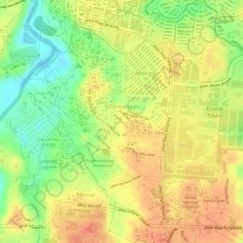
Name: Kademangan topographic map, elevation, terrain.

Location: Kademangan, Setu, South Tangerang, Banten, 15313, Indonesia (-6.34651 106.65770 -6.32447 106.67385)

Average elevation: 154 ft

Minimum elevation: 49 ft

Maximum elevation: 217 ft

Other topographic maps

Click on a map to view its topography, its elevation and its terrain.

BSD

Indonesia > Banten > South Tangerang

Average elevation: 108 ft

Sutera Olivia

Indonesia > Banten > South Tangerang

Average elevation: 82 ft

Baruasih

Indonesia > Banten > South Tangerang

Average elevation: 154 ft

Cadasmampar

Indonesia > Banten > South Tangerang > Serpong

Average elevation: 138 ft

Virginia Lagoon

Indonesia > Banten > South Tangerang

Average elevation: 112 ft

Cadasmampar

Indonesia > Banten > South Tangerang

Average elevation: 138 ft

Cadasmampar

Indonesia > Banten > South Tangerang

Average elevation: 138 ft

Caribbean Islands

Indonesia > Banten > South Tangerang

Average elevation: 157 ft

Cadasmampar

Indonesia > Banten > South Tangerang

Average elevation: 138 ft

Pamulang

Indonesia > Banten > South Tangerang

Average elevation: 200 ft

BSD

Indonesia > Banten > South Tangerang

Average elevation: 108 ft

De Latinos

Indonesia > Banten > South Tangerang

Average elevation: 151 ft

BSD

Indonesia > Banten > South Tangerang

Average elevation: 108 ft

Pamulang

Indonesia > Banten > South Tangerang

Average elevation: 200 ft

Gear up for your next adventure:

📡GPS Antenna Upgrade - Enhance GPS reception in remote terrain
🛡️Insect Repellent - Protection against bugs during outdoor activities
🔦LED Headlamp - Bright and durable LED headlamp for night navigation
📌Outdoor GPS Map App - Apps and devices for digital topographic navigation
🏫Relief Map Kits - Hands-on tools for teaching landforms and elevation

As an Amazon Associate, this site earns from qualifying purchases at no extra cost to you.