Geolocate

Mabini topographic map

Click on the map to display elevation.

About this map

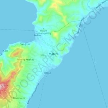
Name: Mabini topographic map, elevation, terrain.

Location: Mabini, Batangas, Calabarzon, 4202, Philippines (13.70769 120.90128 13.78769 120.98128)

Average elevation: 154 ft

Minimum elevation: 0 ft

Maximum elevation: 1,516 ft

Gear up for your next adventure:

🎁Geography Themed Gifts - Unique gift ideas for map lovers and geography enthusiasts
🌧️Backpack Rain Cover - Keep gear dry in wet weather
Backpacking Tents - Weight-optimized shelters for multi-day topographic surveys
🧣Hiking Neck Gaiter - Multi‑use neck protection for outdoor weather
🪶Thermal Camp Blanket - Extra warmth for cold nights

As an Amazon Associate, this site earns from qualifying purchases at no extra cost to you.