Geolocate

Meaford topographic map

Click on the map to display elevation.

About this map

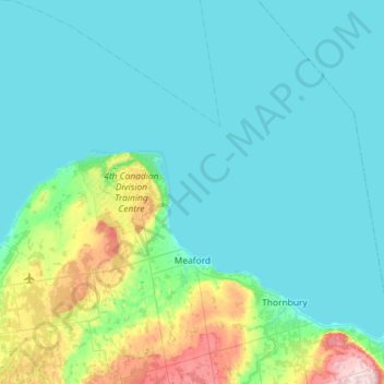
Name: Meaford topographic map, elevation, terrain.

Location: Meaford, Grey County, Southwestern Ontario, Ontario, Canada (44.47455 -80.92573 44.88494 -80.50210)

Average elevation: 728 ft

Minimum elevation: 568 ft

Maximum elevation: 1,706 ft

Other topographic maps

Click on a map to view its topography, its elevation and its terrain.

Markdale

Canada > Ontario > Grey County > Grey Highlands

Average elevation: 1,381 ft

The Blue Mountains

Canada > Ontario > Grey County

Average elevation: 869 ft

Thornbury

Canada > Ontario > Grey County

Average elevation: 663 ft

Kemble

Canada > Ontario > Grey County > Georgian Bluffs

Average elevation: 797 ft

Gear up for your next adventure:

🥩Freeze-Dried Meals - Nutritious and lightweight food for remote expeditions
🧢Sun Protection Hats - Wide-brimmed and UPF-rated hats for high-altitude sun safety
🎒Gear Packing Cubes - Organize your backpack efficiently
🛶Inflatable Kayak - Portable kayak for rivers, lakes, and expeditions
🩹Survival Bandages - High‑quality bandages for emergencies

As an Amazon Associate, this site earns from qualifying purchases at no extra cost to you.